Saab Announces new 3D Global Terrain Database Solution with Vricon
Saab today announced a new aeronautical database solution that will provide the aircraft industry the most advanced 3D global terrain and elevation data commercially available. This new 3D global terrain database solution is in partnership with Vricon.
The Saab partnership with Vricon sets the new standard for advanced avionics systems and flight decks, including applications for Synthetic Vision Systems (SVS), Terrain Awareness Warning Systems (TAWS), digital moving maps, and more. Saab currently is pursing EASA DAT Type 1 certification (equivalent to FAA LOA Type 1) with planned approval in 2020.
“This unique database solution offers unmatched operational and safety advantages that modernizes the flight deck of today and the future. We are proud to be working together with Vricon to make this significant innovation commercially available and to equip the industry with today’s most advanced aeronautical database technology,” says Jan Widerström, head of business unit Avionics Systems, within Saab business area IPS.
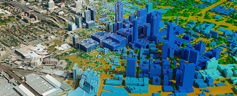
The Saab high-resolution 3D database provides superior global coverage, accuracy, integrity, and continuity—including denied areas—compared to any digital terrain data solution on the market. Traditional aeronautical databases rely on NASA’s decades-old Shuttle Radar Topography Mission (SRTM) data, which is very limited. SRTM data lacks detail and resolution in lower altitudes, is often incomplete in many geographic locations, and only meets minimum regulatory requirements, presenting end-users with technology that fails to meet the demands of today’s flight operations.
“Vricon is very pleased to support Saab and help create the new aeronautical database solution. Through this partnership to support the business jet industry, Vricon’s products will reach a new set of clients, who will benefit from our world-class 3D data and greater assurance for flight operations worldwide,” says Magnus Brege, Vricon’s CEO.
Using Saab’s unique technology that combines the world’s largest source of archive satellite data with robust multi-view stereo algorithms, the database delivers 3D elevation data sets with accuracy better than 3m SE90, with no ground control points required, and 0.5m resolution that includes photo-realistic imagery layered on 3D elevation, greatly enhancing a pilot’s situational awareness. Saab’s technology now forms the foundation of the next generation primary flight display, a performance based SVS.
For further information, please contact:
Saab’s press centre
+46 (0)734 180 018
presscentre@saabgroup.com
Follow us on Twitter: @saab
Saab serves the global market with world-leading products, services and solutions within military defence and civil security. Saab has operations and employees on all continents. Through innovative, collaborative and practical thinking, Saab constantly develops, adapts and improves new technology to meet the changing requirements of customers.